Showing posts with label Relaxing. Show all posts

Saturday, January 19, 2013

Zheravna (attractive tourist destination in Bulgaria)


The village has 330 houses and 550 inhabitant. It is an architectural and ethnographic reserve of over 150 houses, a workshop for church candles, a small school, a convent, a church, 8 drinking-fountains, inns and shops, preserved from the time of the National Revival period. Some of them are over 300 years. Every of them is unique monument to the culture,created from unknown master. The village originated between the 12th-14th century. In the 17th-18th century it gained in wealth mostly due to the development of handcrafts, stock-breeding and trade. At that time the typical Zheravna wooden house took shape. Houses, churches, schools and other buildings have been preserved and turned into museums. Zheravna is the birthplace of Yordan Yovkov, an outstanding Bulgarian writer, whose house is now a museum.

Zheravna is situated in the eastern part of the country, in the middle of the Bulgarian Balkan mountains. It is located 55km from Sliven, near to town Kotel. The distance between Zheravna and the Black sea is only 110 km. Zheravna is the best place to spend your vacation. Opyimum geographic position and mountainous relief to Zheravna give an opportunity to relaxation and tourism. Excursions, picnics, fishing, photo-tourism and ecological walks. That is only part of attractions to Zheravna.

Into the bosom of Zheravna-between the cobblestone alleys, behind the tall fence walls, to uncover the flowered gardens, the intricate woodcarvings and traditional furnishing of the Bulgarian Renaissance home.

The Harimandir (a living symbol of spiritual )


The Harimandir, now called the Golden Temple is a living symbol of spiritual and historical traditions of the Sikhs. The Golden Temple is witness to the high skill of the traditional craftsmen. Its location in the center of the pool would symbolize the synthesis of nirgun and sargun: the spiritual and temporal realms of human existence. Its architecture represents a unique harmony between the Muslims and the Hindus way of construction work and this is considered the best architectural specimens of the world.

It is often quoted that this architecture has created an independent Sikh school of architecture in the history of art in India. The body of water is framed on all four sides by a backdrop of bright-white buildings. The bridge is connected with the 13 feet wide “Pardakshna“. It runs round the main shrine and it leads to the “Har ki Paure” (steps of God). On the first floor of “Har ki Paure“, there is continuous reading of Guru Granth Sahib.

The door frame of the arch is about 10ft in height and 8ft 6inches in breath. The door panes are decorated with artistic style. It opens on to the causeway or bridge that leads to the main building of Sri Harmandir Sahib. It is 202 feet in length and 21 feet in width. At the top of the first floor 4 feet high parapet rises on all the sides which has also four “Mamtees” on the four corners and exactly on the top of the central hall of the main sanctuary rises the third story. It is a small square room and have three gates . A visit to the Golden Temple is incomplete without a visit to the following among others – Akal Takhat, Baba Atall, Guru Ka Langar, Sri Guru Ram das Niwas and The Sgpc officcers.

The Golden Temple, and the city of Amritsar itself, are best visited in the winter. The months between November and March are pleasant (even cold), although the summer can get blisteringly hot. About Golden Temple offers you holiday packages, leisure tour packages, business tour packages and pilgrimage tour packages at best available prices. Travel to Amritsar with about Golden Temple and have a memorable experience of staying in best hotels in Amritsar along with a visit to nearby religious places including Golden Temple. You must visit historical landmarks like Jallianwala Bagh and Ram Bagh.

The construction of Golden Temple at a lower level was a break away from the Hindu tradition of constructing a temple at a higher level. It was done to make the visitors go down the steps in order to pay homage to the holy shrine. 

Sunday, December 30, 2012

Lake Toba (a Heaven on Earth Beauty)


Lake Toba is a large lake, 100 km long and 30 km wide, in the middle of the northern part of the Indonesian island of Sumatra, Indonesia. When you see it you will probably be amazed of its natural beauty and lovely landscapes, but do not forget how it was formed in the past. The enormous inland lake has a history spoken of in local myths, but the true story of Toba and how this enormous inland lake evolved, lies in knowing the story of its Toba volcano.

In 1949 the Dutch geologist Rein van Bemmelen reported that Lake Toba was surrounded by a layer of ignimbrite rocks, and that it was a large volcanic caldera. Later researchers found rhyolite ash similar to that in the ignimbrite around Toba (now called Young Toba Tuff to distinguish it from layers deposited in previous explosions) in Malaysia and India, 3000 km away. Oceanographers discovered Toba ash, with its characteristic chemical “fingerprint”, on the floor of the eastern Indian Ocean and the Bay of Bengal.

 The Toba eruption occurred at what is now Lake Toba about 75 000 years ago. It had an estimated Volcanic Explosivity Index of 8 (which is known as mega-colossal), making it possibly the largest volcanic eruption within the last two million years. According to the researches made by Bill Rose and Craig Chesner of Michigan Technological University the total amount of erupted material was about 2800 cubic km (670 cubic miles) — around 2000 cubic kilometres of ignimbrite that flowed over the ground and around 800 cubic kilometres that fell as ash, with the wind blowing most of it to the west. By contrast, the 1980 eruption of Mount St. Helens in United States ejected around 1 cubic km of material, whilst the largest volcanic eruption in historic times, at Mount Tambora in 1815, emitted the equivalent of around 100 cubic kilometres of dense rock and created the “Year Without a Summer” as far away as North America.

To give an idea of its magnitude, consider that although the eruption took place in Indonesia, it deposited an ash layer approximately 15 cm (6 in) thick over the entire Indian subcontinent; at one site in central India, the Toba ash layer today is up to 6 m (20 feet) thick and parts of Malaysia were covered with 9 m of ashfall. In addition it has been calculated that an amount of 1010 metric tons of sulphuric acid was ejected into the atmosphere by the event, causing acid rain fallout.
The subsequent collapse formed a caldera that, after filling with water, created Lake Toba. The island in the southern part of the lake is formed by a resurgent volcanic dome.

The Lake Toba is definetely a place to visit if you are in Indonesia. The main nearest to the lake town is Parapat, which is about 4 hours by car from Medan (4-6 hours by public bus). Local transportation around the lake takes the form of boats (cheaper, school boats with limited schedules and more expensive public boats that operate throughout the day). You can also hire a motorcycle for a day or two and get out and about (Rp.50,0000 per day inclusive of 4 litres of petrol). There are no police checking licences and there is not much traffic – just watch out for the big trucks, buses and diabolical bridges. A good journey to take on a motorcycle would be to travel North from Tuk Tuk around to the western shore, stopping at the tourist sites along the way such as the many and varied traditional houses. Motorcycles are almost always semi-automatic meaning there is no need to use a clutch to change the foot-operated gears.

Tabo Cottages is the most luxurious accommodation on the island. Prices start at around Rp.120,000 per night and climb up from there. The rooms are very clean and quite modern by Sumateran standards. Internet is available from the family’s computer for a nominal rate and the western-styled food served in the restaurant is very good.

You can eat at Jenny’s Restaurant on Samosir Island, Tuk Tuk. There is only one or two roads in Tuk Tuk, so simply ask for Jenny’s. Jenny and her husband Rinto run the very simple but cozy restaurant with view on the wonderful lake Toba. You will notice that every day the table cloth are being changed, a usually rare to find nicety and convenience. The curry is delicious. A must-try is the fresh lake-fish, steamed or grilled. Even western food like Schnitzel (breaded pork or chicken chop pan fried) is very good. For dessert try the fresh papaya that grows in the back-yard or a golden-brown banana pancake with chocolate sauce and a sprinkle of coconut. Once all the guests in the small place with only about 5 tables are fed and happy, Rinto will take the guitar from the wall and entertain his patrons. When he is singing old Batak songs about earlier times and you listen to the guitar tunes and his melancholic voice, your eyes wander over the lake and you feel like never leaving Samosir again.
A journey to Lake Toba will be definetely a great travel exprerience for you!

Thursday, December 27, 2012

The Bamiyan Buddhas (the most impressive Buddhist monuments in western Asia)


The Bamiyan Buddhas were among the most impressive Buddhist monuments in western Asia before their demolition in March 2001. No one knows exactly when they were constructed, but it was likely that they were erected sometime in the 4th or 5th century AD. For many centuries they stood sentinel to groups of wandering monks and merchants along the famous “silk road” from Rome to China. Alongside the Buddhas, monasteries once existed here as places of sanctuary, but were abandoned in the 9th century as Islam displaced Buddhism in Afghanistan.


The two Buddha figures were commonly classified as the larger and smaller one (53 and 38 meters, respectively). They were once covered with a mixture of mud and straw that had worn away long ago. The straw was covered with plaster and painted to model the rich expressions of the face, hands, and robes. Long before their destruction this year, both the plaster covering and the surrounding cave paintings were rubbed away.

The Buddhas were destroyed following the Taliban’s assertion that the statues were idolatrous. With the swift collapse of the Tabliban in November, 2001, a team of Swiss preservationists has announced plans to restore the statues using precise three-dimensional data collected in the 1970s. However, the United Nations recommended in early 2002 that the monuments not be restored as a reminder of the Taliban’s destructive legacy.


Lizard Island (A place of timeless natural beauty rich in history and spirit)


This boutique Island resort is ‘one of one’ with a stylish and relaxed charm that is set to captivate and delight.

Dining is one of Lizard’s many pleasures… Share the panoramic coastal views while dining seated on the broad sweeping verandah, or enjoy an intimate dinner beachside in a private marquee. The menu is fresh, creative and contemporary – appealing in every respect.The Pavillion at Lizard Island holds ancient secrets and embraces a total harmony between health, beauty and nature. Allow yourself to be captivated by the pavillions earthy ambience… Indulge in the serenity of the spa and delight in total relaxation or enjoy the gym for active workouts.
Imagine beaches so pristine, so untouched, that yours are the only footsteps in the sand…. You’ll discover the beaches of your dreams on Lizard Island and delight in exploring them on foot or by motorised dinghy. Take a gourmet picnic lunch and find a private beach to enjoy. White sands meet crystal clear waters and below the surface a myriad of colour and life awaits discovery. Snokellers are rewarded for little effort, coral gardens, brightly coloured tropical fish and giant clams are a few of Lizard Island’s magical underwater sights.

Discover the variety of diving and snorkelling attractions that have made Lizard Island an international favourite. From coral gardens to the dramatic channel drop-offs and the famous ‘Cod Hole’ with its friendly residents, the Great Barrier Reef offers beauty beyond belief.

Hotel Amenities
-Overview
This premier resort off the coast of North Queensland is also a national park that features an idyllic lagoon and numerous vanilla sand beaches. Asian-influenced accommodations bespeak serene coastal chic
- stylish villas, suites and guestrooms all offer a private deck, balcony or veranda and superb sea views. Here you’ll be treated to full-spectrum hospitality as you enjoy a true reef encounter. The ocean calls with snorkeling in a garden of giant clams and renowned scuba diving at the world famous Cod Hole, where you’ll come face to face with a massive potato cod that swims right up to inspect you. Learn the true meaning of “seclusion” with a picnic lunch on a private beach. Set out on a magnificent walk and glimpse a monitor, the lizard after which the island was named. Explore the surrounding waters in a catamaran, then be touched by a massage at the Azure Spa.

-Restaurants and Amenities
-Osprey’s Restaurant, breakfast, lunch, dinner, local seafood, tropical fruits, menu changes daily, picnic hampers available
-Bar, lounge, Austrailian wines, liqueurs, spirits
-Beach, , water sports, surfing, glass bottom boat trips, catamarans, motorized dinghies, deepwater diving, snorkeling available
-Guided nature walks
-Freshwater pool
-Book, games room
- Azure Spa, range of treatments, massages, gymnasium
-Tennis court, night/day
-Island boutique
-Guest departure lounge, television, Internet access
- Meeting rooms
-Concierge, laundry service, safe deposit boxes, fax, currency exchange, postal service, first aid clinic
-Child Policy
Children 13 and older are allowed
Location
- Lizard Island is the northernmost Great Barrier Reef resort, 27 km off the Queensland coast, 240 km, north of Cairns
- Regular flights are available from all Australian capital cities to Lizard Island (LZR) daily via Cairns, CNS
Room Amenities
-Room Descriptions
Anchor Bay Room: Located in a tropical garden setting with easy access to Anchor Bay and the beach, Anchor Bay Rooms have a private balcony with hammock. Interiors are compact but comfortable. Family Rooms offer two separate sleeping areas.

Anchor Bay Suite: Set in a broad sweeping arc along Anchor Bay, with easy access to the main Lodge, Anchor Bay Suites offer captivating sea views and each has a pathway leading directly to the beach. Seamlessly blending indoors and out in an elegant and spacious open plan design, a large verandah with daybed is one of the many designer comforts.
Sunset Point Villa: Sunset Point Villas are set high on Sunset Ridge amongst native eucalyptus bushland. Providing filtered sea views over Anchor Bay or Sunset Beach, these Villas offer privacy and easy access to a string of secluded beaches. Each Villa has a private deck with comfortable Australian timber squatter chairs and a hammock. Inside, the mix of colors and textures creates a calm retreat with the surrounding coastal bushland the inspiration for the understated and elegant design.

Perched high above the Coral Sea and set on the point of Sunset Ridge, The Pavilion combines complete privacy with a spectacular 270 degree panorama of Anchor Bay, Osprey Island and Sunset Beach. Extensively refurbished mid 2003, a new expansive decking area incorporates a private plunge pool, sun lounges and a daybed area, inviting guests to relax and take in the stunning views. Leaving the balcony to stroll down a private path, guests will discover another secluded area where chairs and a table have been perfectly positioned to make the most of sea breezes and gorgeous views. Inside, the Pavilion offers every comfort. Bollinger champagne and a deluxe fruit bowl greet guests on arrival. A laptop computer for downloading and sending emails and high powered binoculars are among some of the special features.

Includes
-All meals, alcoholic and non-alcoholic beverages
-Motorized dinghies, paddle skis, sailboards
-Glass bottom boat trips and many island activities
-Packages and Promotions
-5-night minimum stay required, Sunset Point Villa
-4-night minimum stay required in Apr 2007-Mar 2008, Anchor Bay Room or Suite, Sunset Point Villa, or Pavilion
-All meals, alcoholic and non-alcoholic drinks
- Mortorized dinghies, paddle skis, sailboards

Wednesday, December 26, 2012

Bonaire island (the right place for the amazing vacation)


Bon Bini on Bonaire!
If you want to practice a lot of diffrent sports from scuba diving to windsurfing or just relaxing at the beaches, you`ve just found the right place for the amazing vacation.
One of the most extra ordinary thing to do in Bonaire is to see the wildlife. Iguanas meditatively toast themselves atop the desert rock formations of Washington Slagbaai, while vast orange-pink clouds of flamingoes drift across bone-white salt flats. There are only four places in the world where flamingo colonies breed-Bonaire is one of them. In fact, more flamingoes live on the island than humans. This chariness seems to be unnatural: if nature ever dressed a diva, the flamingo is it. The pink cotton candy feathers, the graceful, wavy neck, and the long sinewy legs all seems to cry “look at beautiful me“.In fact, the birds are so sensitive to noise and intrusion that the slightest disturbance will cause them to quickly flee. They will never come close to people, and on Bonaire, you must go to them. There are two places to see Bonaire’s flamingoes. One is at the Pekelmeer Sanctuary to the south, where the birds flock around the salt ponds; the other at Lake Gotomeer, in Washington Slagbaai National Park in the north.

St. Barts (the dream destination, a good choice)

 
St. Bart- otherwise known as St. Bart, St. Barth, St. Barths, or St. Barthelemy.
You are looking for quiet, nice place just for relaxing under the gigantics palm trees. Well, St. Barts is one of the most magnificient places in the world with lots of these trees. It has beautiful beaches, so take off your shoes, take a walk on the beach and find your palm tree.
One thing is for sure – You’ll never have an experience as pleasant and romantic as what you’ll find on this miraculous French-owned Island.

Out of a crashing, volcanic explosion, came St-Barts, the pearle of the Caribbean. 25 square kilometers of land, 22 beautiful beaches, many luxurious boutiques, hundreds of traditional Creole houses and secret gardens for your dreams of avoidance. Nonchalance, happiness, calm, luxurious, warm – St. Barts has it for you. Your stay will leave you with the elegant souvenir of balmy tropical evenings swayed by the local biguine music, flavored with vanilla and peppered with Caribbean spices. Lazy days, sporty days, the sea is the king, the excellent restaurants, the refinement of the hotels…everything you need to spend a good vacation.


Monday, December 24, 2012

Taal Volcano and Lake ()ManilaOne of the most visited tourist spots in the Philippines


One of the most visited tourist spots in the Philippines, is a geological phenomenon a volcano within a lake within a volcano. Taal is the world’s smallest volcano, but do not let appearances deceive you, it can be quite deadly when it erupts. A 45-minute ride on a banca (wooden boat) will take you to the volcano, a 15-minute trek will take you to the top of the crater. An older and larger volcano is an hour away, which requires the assistance of an experienced guide.

  The volcano has erupted violently several times, causing loss of life in the populated areas surrounding the lake. Due to its eruptive history and location close to population centres, the volcano has been designated a Decade Volcano worthy of close study to prevent future natural disasters.Taal Volcano is part of a chain of volcanoes along the western side of the island of Luzon, all formed by the subduction of the Eurasian Plate underneath the Philippine Plate. Taal Lake lies within a 25–30 km caldera formed in four giant explosive eruptions between 500,000 and 100,000 years ago. Each of these eruptions created extensive ignimbrite deposits, reaching as far away as where Manila stands today. So if you are goind to the Taal Volcano i may advise you to wear jeans or rough clothes cause it is very dusty. You should also wear a hat which can be purchased as you get off boat. It is indeed a nice souvenier. Great day/value you can haggle price from P2500 down to P1500.
Google Earth Placemark

Friday, December 21, 2012

The Easter Island (One of the world’s most famous archaeological sites)


One of the world’s most famous yet least visited archaeological sites, Easter Island is a small, hilly, now treeless island of volcanic origin. It is located in the Pacific Ocean at 27 degrees south of the equator and some 2200 miles (3600 kilometers) off the coast of Chile, it is considered to be the world’s most remote inhabited island.

The Easter Island, known in the native language as Rapa Nui (“Big Rapa”) or Isla de Pascua in Spanish, is sixty-three square miles in size and with three extinct volcanoes (the tallest rising to 1674 feet). The oldest known traditional name of the island is Te Pito o Te Henua, meaning The Center (or Navel) of the World. In the 1860’s Tahitian sailors gave the island the name Rapa Nui, due to its resemblance to another island in Polynesia called Rapa Iti, meaning ‘Little Rapa’. The island received its most well known current name, Easter Island, from the Dutch sea captain Jacob Roggeveen who became the first European to visit Easter Sunday, April 5, 1722.

 That culture’s most famous features are its enormous stone statues called moai, at least 288 of which once stood upon massive stone platforms called ahu. There are some 250 of these ahu platforms spaced approximately one half mile apart and creating an almost unbroken line around the perimeter of the island. Another 600 moai statues, in various stages of completion, are scattered around the island, either in quarries or along ancient roads between the quarries and the coastal areas where the statues were most often erected. Nearly all the moai are carved from the tough stone of the Rano Raraku volcano. The average statue is 14 feet, 6 inches tall and weighs 14 tons. Some moai were as large as 33 feet and weighed more than 80 tons (one statue only partially quarried from the bedrock was 65 feet long and would have weighed an estimated 270 tons). Depending upon the size of the statues, it has been estimated that between 50 and 150 people were needed to drag them across the countryside on sleds and rollers made from the island’s trees.

Most moai were carved out of a distinctive, compressed, easily-worked volcanic ash or tuff found at a single site called Rano Raraku. The quarry there seems to have been abandoned abruptly, with half-carved statues left in the rock. However, on closer examination the pattern of use and abandonment is more complex. The most widely-accepted theory is that the statues were carved by the ancestors of the modern Polynesian inhabitants (Rapanui) at a time when the island was largely planted with trees and resources were plentiful, supporting a population of at least 10,000–15,000 native Rapanui. The majority of the statues were still standing when Jacob Roggeveen arrived in 1722. Captain James Cook also saw many standing statues when he landed on the island in 1774. By the mid-19th century, all the statues had been toppled, presumably in internecine wars.

Ancient island legends speak of a clan chief called Hotu Matu’a, who left his original home in search of a new one. The place he chose is now known to us as Easter Island. When he died, the island was divided between his six sons and later sub-divided among their descendants. The islanders may have believed that their statues would capture the chiefs’ “mana” (supernatural powers). They may have believed that by concentrating mana on the island good things would result, e.g., rain would fall and crops would grow. The settlement legend is a fragment of what was surely a much more complicated and multi-faceted, mythic sketch, and it has changed over time.
Really amazing are these stone giants just sitting there for such a long time. I will be for sure a journey of a lifetime to get there and see them i think.

Colosseum of Rome (the Most Dramatic Historic Monuments on Earth)


The Colosseum – the greatest amphitheatre of the antiquity – was built in Rome, Italy, about 1920 years ago. It is considered an architectural and engineering wonder, and remains as a standing proof of both the grandeur and the cruelty of the Roman world.
The Colosseum or Coliseum, originally known as the Flavian Amphitheatre, is a giant amphitheatre in the centre of the city of Rome. Originally capable of seating 50,000 spectators, it was used for gladiatorial contests and public spectacles. It was built on a site just east of the Roman Forum, with construction starting between 70 and 72 AD under the emperor Vespasian. The amphitheatre, the largest ever built in the Roman Empire, was completed in 80 AD under Titus, with further modifications being made during Domitian’s reign.

The Colosseum remained in use for nearly 500 years with the last recorded games being held there as late as the 6th century — well after the traditional date of the fall of Rome in 476. As well as the traditional gladiatorial games, many other public spectacles were held there, such as mock sea battles, animal hunts, executions and dramas based on Classical mythology. The building eventually ceased to be used for entertainment in the early medieval era. It was later reused for such varied purposes as housing, workshops, quarters for a religious order, a fortress, a quarry and a Christian shrine.
 Although it is now in a severely ruined condition due to damage caused by earthquakes and stone-robbers, the Colosseum has long been seen as an iconic symbol of Imperial Rome and is one of the finest surviving examples of Roman architecture. It is one of modern Rome’s most popular tourist attractions and still has close connections with the Catholic Church, whose Pope leads a torchlit procession to the amphitheatre each Good Friday.The Colosseum measures 48 metres (157 ft / 165 Roman feet) high, 189 metres (615 ft / 640 Roman feet) long, and 156 metres (510 ft / 528 Roman feet) wide. Unlike earlier amphitheatres, it was an entirely free-standing structure, constructed on flat ground rather than being built into an existing hillside or natural depression. Its outer wall originally measured 545 metres (1,788 ft / 1,835 Roman feet) and is estimated to have required over 100,000 cubic meters (3,531,466 ft) of travertine stone held together by 300 tons of iron clamps.
The surviving part of the outer wall’s monumental facade comprises three stories of superimposed arcades surmounted by a podium on which stands a tall attic, both of which are pierced by windows interspersed at regular intervals. The arcades are framed by half-columns of the Doric, Ionic, and Corinthian orders, while the attic is decorated with Corinthian pilasters. Each of the arches in the second- and third-floor arcades framed statues, probably honoring divinities and other figures from Classical mythology.
The Colosseum’s huge crowd capacity made it essential that the venue could be filled or evacuated quickly. Its architects adopted solutions very similar to those used in modern stadiums to deal with the same problem. The amphitheatre was ringed by eighty entrances at ground level, 76 of which were used by ordinary spectators. Each entrance and exit was numbered, as was each staircase. The northern main entrance was reserved for the Roman Emperor and his aides, whilst the other three axial entrances were most likely used by the elite.
The arena itself was 83 metres by 48 metres (272 ft by 157 ft / 280 by 163 Roman feet).It comprised a wooden floor covered by sand (the Latin word for sand is harena or arena), covering an elaborate underground structure called the hypogeum (literally meaning “underground”). Little now remains of the original arena floor, but the hypogeum is still clearly visible. It consisted of a two-level subterranean network of tunnels and cages beneath the arena where gladiators and animals were held before contests began. Eighty vertical shafts provided instant access to the arena for caged animals and scenery pieces concealed underneath; larger hinged platforms, called hegmata, provided access for elephants and the like. It was restructured on numerous occasions; at least twelve different phases of construction can be seen.
Hollywood movies reinforced some widespread false impressions about the Colosseum of Rome. Historians doubt that the wholesale martyring of Christians occurred there. And, the image of lions eating the Christians before cheering crowds is likely fantasy. Films have also bolstered the myth that thumbs down meant to kill the person in the arena. It was just the opposite in Roman times. Thumbs up signaled “kill him” and thumbs down, “spare him.”

The Colosseum – Entry €11 (€9 if you’re under 25). Expect a long queue and an even longer wait. You can skip the queue if you decide to take a tour, but if you don’t want a tour, you can STILL skip the queue. If you walk across the street to the Roman Forum, you can buy a day-long pass for €10,better still, a 7-day pass for €20 or a standard Colosseum + Palatine ticket at €11. This pass gets you in to the Colosseum, Palatine Hill, the Baths of Caracalla, and the catacombs. If you don’t want to cram it all into one day, get the pass. Plus, it is nice to buy a slice of pizza and eat in the gardens of Palatine Hill. There are lots of people offering tours in English just outside the entrance to the Colosseum. Inside you can take a tour (English, Spanish, or German) every 30 minutes or so for an additional fee of €3.5 per person. The tours are given by knowledgeable archeologists, but they don’t take you to any areas you couldn’t visit on your own.

Thursday, December 20, 2012

The Parthenon (the one historical site you can’t miss)


What would a visit to Athens, Greece be without going to the Acropolis to see the Parthenon? The Acropolis is the one historical site you can’t miss. You can take a tour or wander up there yourself but during the summer, whatever you do, unless it is overcast, go early or late in the day. It can get very hot up there and gasping for breath can take way from your ability to marvel at the greatest of all archaeological sites. The Acropolis rises sharply from the plain of Attica with steep cliffs on three sides. It is accessible by foot only to the west, where it is linked by a low ridge to the hill of the Areopagus. It is formed by a layer of blue-grey limestone, which is very hard but water-permeable. This rests on a layer of schist-sandstone marl, softer than the limestone but water-impermeable. This arrangement leads to the ready formation of artesian springs, as well as sheltered caves at the hill’s feet, which was also a factor that attracted human habitation on and around the rock.

Getting to the Acropolis is easy and more pleasant than ever because the large avenues which border the south and west of the site (Apostolou Pavlou in Thission and Dionissiou Areopagitou in Makrianni) have been turned into giant pedestrian streets with cafes and restaurants and the walk is quite pleasant. From the Plaka and Monastiraki side it has always been a car-less, enjoyable walk and all you have to do is walk uphill from wherever you are and when you get to the top and there are woods instead of buildings, and steps, take a right.
After climbing the steps you are at the entrance, or the Propylaea, which was completed in 432 just before the outbreak of the Peloponnesian wars. The main architect was Mnesicles, a colleague of Phidias. To your left is the Pinacotheca and a Hellenistic pedestal and on the right the tiny temple to Nike Athena or the Athena of Victory which commemorates the Athenians victory over the Persians. This small temple stands on a platform that overlooks the islands of Saronic Gulf and used to house a statue of Athena. It was dismantled by the Turks in 1686 so they could use the platform for a large cannon. It was rebuilt between 1836 and 1842 and again taken apart and rebuilt in 1936 when it was discovered that the platform was crumbing. If you looking from the propylaea towards Pireaus on a clear day you can see ships waiting outside the port of Pireaus, the islands and the mountains of the Peloponessos beyond.

The Parthenon and other main buildings on the Acropolis were built by Pericles in the fifth century BC as a monument to the cultural and political achievements of the inhabitants of Athens. The term acropolis means upper city and many of the city states of ancient Greece are built around an acropolis where the inhabitants can go as a place of refuge in times of invasion. It’s for this reason that the most sacred buildings are usually on the acropolis. It’s the safest most secure place in town. As little as 150 years ago there were still dwellings on the Acropolis of Athens
Every four years the Athenians held a festival called the Panathenaea that rivalled the Olympic Games in popularity. During the festival, a procession moved through Athens up to the Acropolis and into the Parthenon (as depicted in the frieze on the inside of the Parthenon). There, a vast robe of woven wool (peplos) was ceremoniously placed on Phidias’ massive ivory and gold statue of Athena.

The best time to go up there is the late winter or spring when even this stone mountain is not immune to the proliferation of grass and wildflowers which seem to burst from every crack. Even in December, January and February the Acropolis can be surprisingly green.
The Acropolis is open from 8am to 6:30 pm every day. These hours can change depending on the season and sometimes it is open in the evening of the full moon in the summer. They don’t allow you to bring backpacks or day bags on the Acropolis. You have to check them so if you need to bring a bag with you be sure to have a spare pocket for your valuables. The cost of entrance to the Acropolis is about 12 euros and is good for the other sites in the area including the ancient agora, theatre of Dionysos, Kerameikos, Roman Agora, Tower of the Winds and the Temple of Olympian Zeus and is supposedly good for a week. You can also buy individual tickets to these other sites. One way to get to the Acropolis is to walk up from the Plaka and keep climbing until you come to the small road that goes around it and head west (to your right). The entrance is up from the rock of Areopagos. The easiest way is to follow Dioysiou Aeropagitou, the large pedestrian street that starts near Hadrian’s Arch and goes around the north of the Acropolis until you come to the marble paths that lead up the hill. This road becomes Apostolou Pavlou which is also car-less and continues past the cafes of Thission to the lower Ermou and Kerameikos archaeological site which is at the bottom of Monastiraki.


Tuesday, December 18, 2012

The Cook Islands (a paradise)


The Cook Islands are a Polynesian paradise consisting of fifteen islands scattered over some one million square miles of the Pacific Ocean. They lie at the center of the Polynesian Triangle of the South Pacific with Tonga and the Samoas to the west, and Tahiti to the east. They are in the same time zone as Hawaii and are the same distance south of the Equator as Hawaii is north. The Cook Islands are self-governed, but their benevolent big brother, New Zealand, watches over them and takes care of the mundane necessities of life—banking, post offices, medical facilities, communication, hotel managing, etc. The New Zealand dollar is the official currency and although Maori is the local language, everyone speaks English. The Kiwi laid back philosophy prevails throughout the islands.

Most of the Cook Islands population resides on Rarotonga, the main island. Its capital town of Avarua is the heart of the Cook Islands. Polynesian heritage is evident in the dance and drama performed at various events throughout the year, particularly during the Constitutional Celebration on August 4th. The people are simply lovely—warm, friendly and welcoming of island guests. The climate of the Cooks is pleasantly warm and sunny all year round. From April to November are the cooler and drier months, while November to March marks the warmer season with occasional tropical showers. Severe weather is very rare in the islands. The Cook Islands are a great stopover on the way to New Zealand or Australia or if you are island hopping around the South Pacific.


Crown Beach Resort, the newest 4-star property on the Cook Islands, is located on the sunset side of Rarotonga. Combining genuine island hospitality, gorgeous surroundings and excellent accommodations, the resort is an exclusive tropical getaway for divers, honeymooners and families. The resort`s gardens are beautifully kept, the lagoon safe to swim at any tide, and there is a large freshwater pool. Relax by the pool with drinks from the pool bar, have a game of beach volleyball, windsurf, kayak, rent a motorcycle and explore the island, or swim and snorkel in the lagoon. Golf is available nearby, and scuba diving is excellent here. For children there are escorted children`s activities, and baby-sitting can be arranged. The resort`s tour desk is able to organize village visits, island tours, game fishing, island treks, horseback riding and many other activities. And after a fabulous active day, enjoy a romantic dinner at the resort`s Windjammer

Pyramids of Egypt (One of the world most amazing)


One of the world most amazing, breathtaking and ranked by many many people as Number One Wonder of the World are Pyramids made by ancient egyptians in the plateau of Giza. The Pyramids of Egypt are so massive they confound the imagination. They are even more amazing when we consider that they were built nearly 4600 years ago. There are no more famous ancient sites within Egypt, or for that matter elsewhere in the world, than the Great Pyramids at Giza. They are, without question, the icon most associated with the Egypt.

The Giza Necropolis ( Google Earth Placemark – Pyramids of Egypt travel wonder at Giza ) stands on the Giza Plateau, on the outskirts of Cairo, Egypt. This complex of ancient monuments is located some eight km inland into the desert from the old town of Giza on the Nile, some 20 km southwest of Cairo city centre. This Ancient Egyptian necropolis consists of pyramids. Pyramid of Khufu (also known as the Great Pyramid and the Pyramid of Cheops), the somewhat smaller Pyramid of Khafre (or Chephren), and the relatively modest-size Pyramid of Menkaure (or Mykerinus), along with a number of smaller satellite edifices, known as “queens” pyramids, causeways and valley pyramids, and most noticeably the Great Sphinx. Associated with these royal monuments are the tombs of high officials and much later burials and monuments (from the New Kingdom onwards) associated with the reverence to those buried in the necropolis. The Great Pyramid of Giza is the only remaining of the Seven Wonders of the World. Most Egyptologists agree the pyramid was constructed over a 20 year period concluding around 2560 BC. It is generally believed the Great Pyramid was built as the tomb of Fourth dynasty Egyptian pharaoh Khufu (Cheops), after whom it is sometimes called Khufu’s Pyramid or the Pyramid of Khufu.

The Great Pyramid is the oldest and largest of the three pyramids in the Giza Necropolis bordering what is now Cairo, Egypt in Africa. It is the main part of a complex setting of buildings that included two mortuary temples in honor of Khufu (one close to the pyramid and one near the Nile), three smaller pyramids for Khufu’s wives, an even smaller “satellite” pyramid, a raised causeway connecting the two temples, and small mastaba tombs surrounding the pyramid for nobles. One of the small pyramids contains the tomb of queen Hetepheres (discovered in 1925), sister and wife of Sneferu and the mother of Khufu. There was a town for the workers, including a cemetery, bakeries, a beer factory and a copper smelting complex. More buildings and complexes are being discovered by The Giza Mapping Project.

Khafre’s Pyramid, is the second largest of the ancient Egyptian Pyramids of Giza and the tomb of the fourth-dynasty pharaoh Khafre (Chephren).
The pyramid is believed to have been completed around 2532 BC, at the end of Khafre’s reign. It lies a few hundred meters southwest of its larger neighbor, the Great Pyramid of Khufu, in the Giza necropolis outside of Cairo.
Khafre’s Pyramid had an original height of 143.87 m (275 royal cubits or 471 ft). It now stands at 136 m (446 ft) tall with a base of 215.29 m (410 royal cubits or 704 ft), covering a total area of about 11 acres (45,000 square m). Its angle of incline measures 53 10′ at the top, which is steeper than the Great Pyramid, but at the bottom the angle is lower. The reason for this is that at the base cracks began to form, so the Egyptians decided to lower the entire height of the pyramid. This, and its slightly more elevated location often make Khafre’s Pyramid appear larger than the Great Pyramid. It is, in fact, smaller in both height and volume.

Menkaure’s Pyramid, located on the Giza Plateau on the southwestern outskirts of Cairo, Egypt, is the smallest of the three Pyramids of Giza. It was built to serve as the tomb of the fourth dynasty Egyptian Pharaoh Menkaure.
had an original height of 65.5 meters (215 feet). It now stands at 62 m (203 ft) tall with a base of 105 m (344 ft). Its angle of incline is approximately 51 20″25′. It was constructed of limestone and granite.
The pyramid’s date of construction is unknown, because Menkaure’s reign has not been accurately defined, but it was probably completed sometime during the 26th century BC. It lies a few hundred meters southwest of its larger neighbors, the Pyramid of Khafre and the Great Pyramid of Khufu in the Giza necropolis.
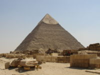
Of the three, only Khafre’s pyramid retains part of its original polished limestone casing, towards its apex. It is interesting to note that this pyramid appears larger than the adjacent Khufu pyramid by virtue of its more elevated location, and the steeper angle of inclination of its construction – it is, in fact, smaller in both height and volume. The most active phase of construction here was in the 25th century BC.
The ancient remains of the Giza necropolis have attracted visitors and tourists since classical antiquity, when these Old Kingdom monuments were already over 2,000 years old. It was popularised in Hellenistic times when the Great Pyramid was listed by Antipater of Sidon as one of the Seven Wonders of the World. Today it is the only one of the ancient Wonders still in existence.
Due largely to nineteenth-century images, the pyramids of Giza are generally thought of by foreigners as lying in a remote, desert location, even though they are located in what is now part of the most populated city in Africa. Consequently, urban development reaches right up to the perimeter of the antiquities site, to the extent that in the 1990s a Pizza Hut and KFC restaurant opened across the road.

The ancient sites in the Memphis area, including those at Giza, together with those at Saqqara, Dahshur, Abu Ruwaysh, and Abusir, were collectively declared a World Heritage site in 1979.
 Interesting tidbits about the Pyramids of Egypt at Giza:
* Many theories exist on how the Pyramids of Egypt were constructed. Most Egyptologists now believe that a large temporary earth ramp with a gentle incline was built. The giant stone blocks were then dragged up the slope with a combination of pulleys, levers and raw manpower.
* Over the course of several centuries, the construction design evolved from the modestly high step pyramid style to the skyscraping, smooth-sided pyramids of Khufu and Chephren at Giza.
* Then, starting with Menkure’s pyramid (the nearest one in the picture), size and structural strength gradually began to decline. The primary reasons were weakening economies and fading pharaonic powers.
* The three great Pyramids of Egypt have a north-south alignment because the polar stars were considered sacred.
* The number of large stone blocks used to build the Pyramids of Egypt is often overstated. For example, it is commonly written that 2,300,000 million were used for Khufu’s structure. The actual figure is many times smaller when you divide the cubic size of the pyramid by the average cubic size of the stone blocks.
* Some archeologists speculate that the tomb robbers were unsuccessful in finding the true burial chambers in the Pyramids of Egypt because the tomb builders were cleverer than the thieves. If so, the pharaonic mummies and treasures are still concealed somewhere within their respective pyramids, waiting to be detected by future technology.